
Curious about the extent of the golf course land, zoning and development permissions, gifted land, and what Core vs Non-Core means?
This document includes a map of the course and simple explanation of these themes. Let us know if you'd like further information on this topic.
Vincentia Golf Course Map
In November 2023, the Shoalhaven Council completed the sale of its 'paper roads' to the Country Club. That means that the roads shown below, marked out by Lots 1, 2, 3 & 4 of DP 1293668, were merged with the core golf course Lot 4 DP 872852, resulting in a new single lot – Lot 1 DP 1301691. There remain a few paper roads, marked in gray by cross-hatching.
The Clubhouse (E) remains a separate Lot 1 DP 545282.
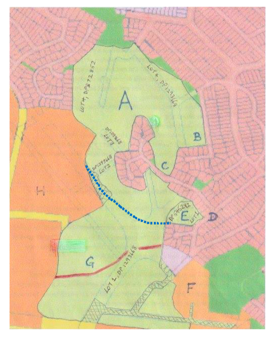
A is the area from top down to the blue dotted line, occupied by the ‘front nine’…holes 1 -9.
B is the 6th hole adjoining Knowles St where a parcel of land was declared non-core for the purposes of the Memorandum of Understanding (MoU). This was because the old VGC Ltd had
partially progressed a proposal to develop this land for a small area of ‘over 55s’ dwellings.
All other land is ‘core’ land and cannot be sold without approval by members at a General Meeting.
C is the entrance to Prowse Close/Louisa Grove/ Cockbourne Place housing.
D is Murray Street.
E is the clubhouse and car park area.
F is the area of environmental land known as 'Lively Street'. This is the Halloran gifted land.
G is the area below the blue dotted line, down to the red line, occupied by the current back four holes 10 – 13.
Below the red line, this area is not developed. Plans were approved for a further five holes 14-18 to complete the ‘back nine’ of an 18 hole course.
H is environmental Crown Land.
Vincentia Golf Course – Development Considerations
Core vs Non-core: all of the course land (in pale green) is ‘core’ land except for B. Core land can re-classified as non-core on approval by members at a general meeting, and then sold. Core land can still be sold without approval to re-classify, but must be at arms’ length. (See below ** for a more detailed explanation).
Halloran Gifted Land: is the environmental area shown at F. It is not of much practical use. (The rest of the course was bought in 1970).
Zoning: The total core land is zoned RE2, and is around 40 Hectares. It is surrounded by land that is zoned C1 (National Parks and Nature Reserves), much of which is also zoned as Bushfire Prone Lands. The golf course then acts as a buffer between the preserved national park vegetation and the local streets/houses.
Seniors living is permissible in this RE2 zone under NSW Government’s State Environmental Planning Policy (SEPP ) (Housing) 2021. A DA can be approved so long as a registered club exists on the property.
Scenario 8: The President has said in his January and February messages that the Board’s “Scenario 8” is a "limited parcel of land" around the Clubhouse and carpark. In his words, "Initial plans suggest a development that would occupy about 5-10% of the existing land."
The stated intent is also to keep a 9 hole course, where the development results in better patronage for the Club.
The full extent of the development will be announced in due course.
For reference in visualising the footprint:
The Club and carpark is approximately 1 hectare.
The current 13 hole golf course is approximately 30 hectares (excluding the undeveloped holes 14 -18 and the Clubhouse).
5% - 10% of that golf course impact equates to 1.5 - 3 hectares.
Written by Rosalie Wood, FoVGC Inc. Vice President
** Additional advice from FoVGC Committee member Rob Christlo regarding what core and non-core means and the implications of this from Country Club and Shoalhaven City Council's perspectives: "The terms core and non-core are used by the Country Club to distinguish how they classify different parts of their land. The VGC property is nearly all core land, with the exception of a smaller parcel adjacent to Knowles Street which was reclassified to non-core prior to the amalgamation taking place. Council and the legislative planning system don't use these terms, and how the Club classifies its land is of no particular interest to Council. The zoning of the land and what is permissible in the zone is what counts when it comes to the planning system. The majority of the VGC land is zoned RE2 under which seniors housing is permissible via State Environmental Planning Policy (Housing) 2021. Rezoning of the land is not necessary for The Country Club, or their agent, to pursue a seniors housing development.